
How to streamline Environmental Noise Directive reporting and solve INSPIRE


Introduction
Environmental noise is a major contributor to stress and health issues. Thus, the reduction of environmental noise pollution in Europe is a clear goal laid out in the European Union’s Environment Action Programme to 2020, “Living well, within the limits of our planet” . The World Health Organization ranks noise pollution second only to air pollution as the largest environmental cause of human health problems.
According to the JRC, prolonged exposure to elevated noise levels above recommended thresholds increases annual hospital admissions and can cause sleep disturbance, hypertension, and even premature death due to heart disease. Awareness of the negative impacts of noise pollution has never been greater, and the availability of high-quality noise source data combined with cutting-edge medical studies on health effects is driving policy change to reduce acceptable noise levels even further.
What is the Environmental Noise Directive?
The Environmental Noise Directive (END) is European legislation aimed at measuring and managing environmental noise in Europe. The END assesses the amount of noise citizens are exposed to, makes the noise assessments open to the public and supports the reduction and prevention of unacceptable noise levels. Noise levels are measured in decibels (dB). Lden and Lnight are noise indicators which describe the average level of noise in the day, evening, and night, and in the night, respectively.
The EU’s leading sources of noise pollution are:
- Road traffic, with an estimated 125 million inhabitants affected by noise levels over 55 decibels (dB).
- Rail traffic, with nearly 8 million people exposed.
- Aircraft noise, 3 million people exposed.
- Industrial noise, with 300.000 thousand people exposed.
Since these are the major source of noise, the END mandates states report and publish noise maps and noise management action plans every five years for the following areas:
- Agglomerations (100,000+ inhabitants)
- Major roads (3 million+ vehicles a year)
- Major railways (30.000+ trains a year)
- Major airports (50.000+ movements a year)
Reporting Environmental Noise Data
European countries report noise data to the European Environmental Agency (EEA) via an infrastructure called Reportnet. In 2007, the Electronic Noise Data Reporting Mechanism was introduced to improve implementers’ ability to deliver noise data using MS Excel templates and shapefile (vector) or ASCII (raster) files.
There have been challenges with this process in the past, especially when data from many different authorities has to be collected, validated and aggregated. As an example, around 100 organisations contribute to END reporting in the Netherlands, and even more contribute in Germany. Furthermore, the data for the 2017 reporting cycle had to be provided twice – one according to the INSPIRE Human Health and Safety theme using GML Application Schema, and one, according to the END ReportNet specifications.
The streamlining of e-reporting obligations has long been a topic of discussion amongst regulators and current developments in the reporting structures of END data reflect the desire to align the requirements with those of INSPIRE.
Wetransform has played a central role in developing the new GeoPackage encoding for the next generation of END e-reporting obligations. In our work, we created GeoPackage templates for the END Data model, which are available in a public GitHub repository. GeoPackage, as an encoding choice, is suitable for the large noise contour datasets which must be delivered. These templates were developed so that they would also comply with the INSPIRE Implementing Rules. A Good Practice is currently being reviewed by the INSPIRE MIG-T. Upon acceptance of the Good Practice, such GeoPackages will be considered compliant with the data specifications of INSPIRE.
Automated END Transformation workflows
In the past months, we have worked together with several national agencies such as the UBA Germany and RIVM from the Netherlands to implement streamlined and automated data collection, validation, and delivery processes. These processes make it easy to collect data from municipalities, transport agencies and other stakeholders. They validate, transform, and publish data as view and download services, complete with INSPIRE.
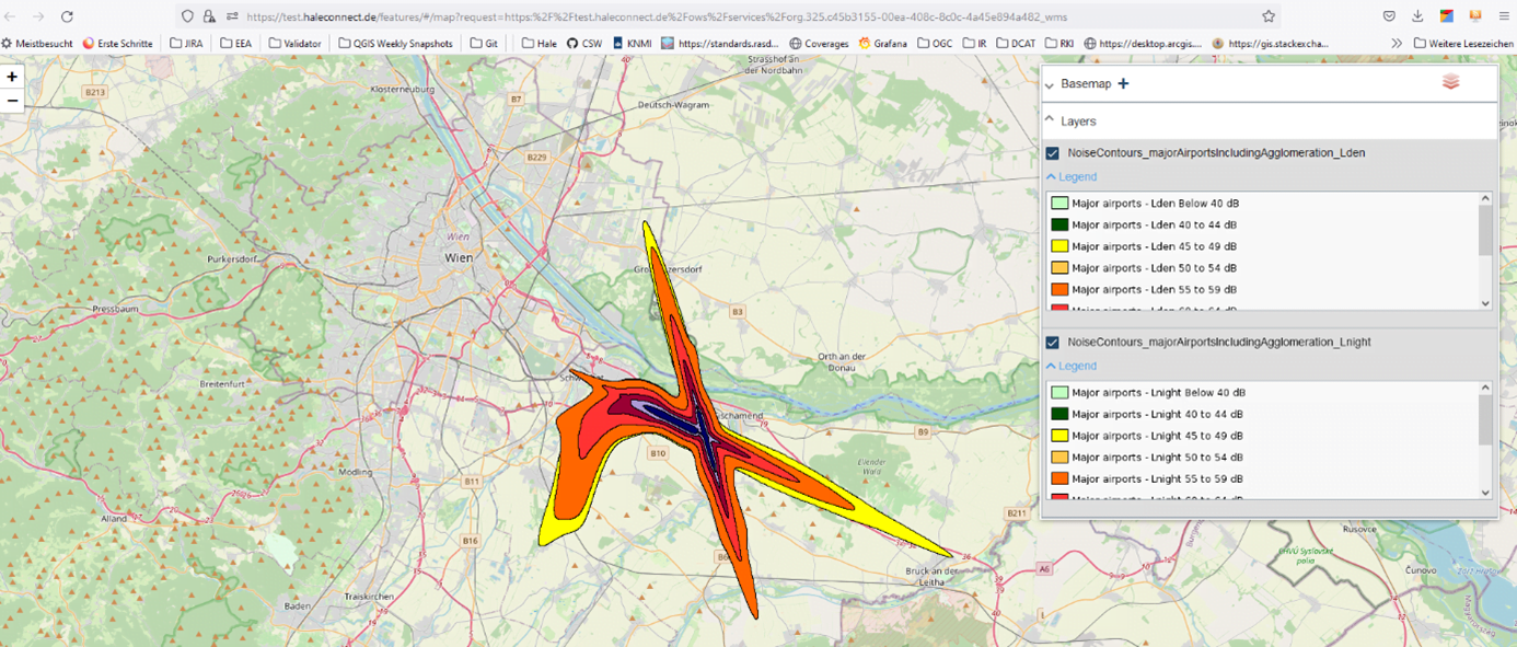
We built these workflows by relying heavily on the automation capabilities of hale»connect. Together, hale»studio and hale»connect support a variety of workflows for publishing END reporting data. END implementers using noise contour shapefiles as source data can transform their source data using the END-compliant GeoPackage schemas, or INSPIRE-compliant GML, in hale»studio. Alternatively, END-compliant GeoPackages can be used as source data and mapped to the INSPIRE Human Health and Safety GML Application Schema, or vice versa. These transformation projects are all supported by hale»connect, allowing end users to schedule automated transformation runs in the cloud when source data experiences updates. Automated online workflows ensure that published data, metadata, and services always reflect the latest and most current state of your data. For example, below you can find END Noise Contours of Major Airports Noise Exposure in Austria.
Support for END Data in hale»studio
The GeoPackage format is central for the new reporting dataflows. hale»studio supports reading and writing GeoPackages and has been used extensively to transform data from a wide range of formats, such as FileGeodatabases, Excel Sheets, Shapefiles or even CSVs into compliant GeoPackages. Example hale studio projects are available from GitHub.
Since version 4.1.0, hale»studio contains the official GeoPackage END schemas as presets. In addition to the basic presets, there are also templates for LineString-based exposure data, as well as templates that contain additional validation rules that are in line with the EEA ReportNet checks for END data flow DF1_5 and DF4_8.
Support for END Data on hale»connect
In the past months, we have extended GeoPackage support on our platform substantially, as described in our latest product release blog. For END, these are the relevant key features:
- GeoPackage schemas can now be used on hale»connect by uploading hale schema defintions. These schemas can contain validation rules to enforce constraints such as using values from codelists, matching regular expressions, and many more.
- hale»connect users can create GeoPackage-based datasets and automatically publish associated view and download services, and generate metadata.
- GeoPackage is now available as a transformation source and target, in online transformation projects. Users working with GeoPackage as the target encoding in hale»studio transformation projects can now use those projects in online transformation configurations on hale»connect.
If you are still looking to optimize your END data collection and reporting process, don’t hesitate to reach out to us to learn about “END reporting as a service”. It’s all built and ready to use ?.
Also look feel free to attend our webinar on END on the 21st of June at 13:00 to learn more about this topic!
Exposure data processing for QGIS
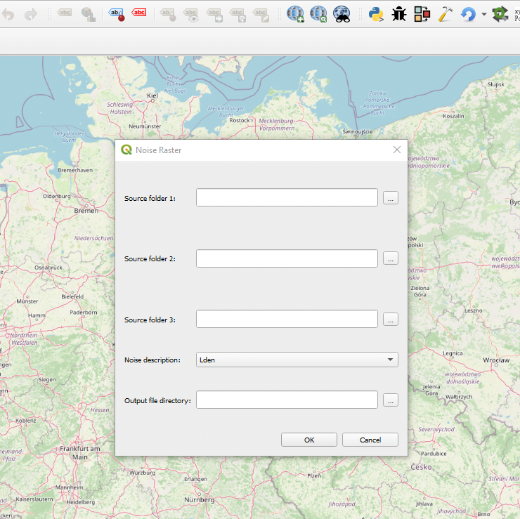
The END workflow D4_8 is aimed at creating strategic noise maps for agglomerations, which are used to assess the number of people exposed to harmful levels of noise . Organizations responsible for reporting D4_8 workflows are required to provide tabular data, as well as noise contour lines or noise contour polygons. In cooperation with UBA Deutschland, wetransform developed a QGIS plug-in to process noise rasters and generate contour polygons.
The tool reads source data from up to three different source folders which contain noise rasters for a specific theme, such as road, rail or airport, based on the same indicator (Lden or Lnight). Several critical properties are validated before processing begins. Raster file extension, coordinate reference system, raster extent, no data values, and cell resolution are assessed and adapted, if necessary, to ensure that all source files can be used together in raster processing operations.
One of the biggest challenges was to optimize the script for fast processing. The tool can process thousands of rasters covering an entire Bundesland (State) in Germany. To do so, several approaches were tested. The tool merges the rasters for each noise source and generates a multi-band virtual raster (VRT), which is used as input for the energetic addition. Overlapping values in the multi-band raster are added together and written to a new raster, which is reclassified using the noise level range values for either Lden or Lnight. The reclassified raster is then converted into polygon contour lines and reprojected to the coordinate reference system required by the EEA, EPSG:3035.
Nearly all the raster processing functions utilized by the tool are standard GDAL functions, except for the native QGIS Reclassify tool, and as such the tool can be used in any standard QGIS installation.
For more information about the tool, visit the GitHub repository.
Learnings and Future Developments
END reporting is an excellent example of using multiple encodings and logical data models for the same conceptual model, to achieve compliance and better data usability.
During the development of the END GeoPackage schemas, we initially applied so-called model transformations manually to derive those multiple logical models.
Currently, we are working on automating this process. It will enable users to export transformed models as *.hsd (Hale Schema Definition) schema files and to automatically create transformation projects to convert from one logical model to another. The scope of this model transformation functionality will not be limited to INSPIRE, or END use cases.
The model transformation is based on a special compatibility mode, similar to the existing modes for XtraServer, GeoServer, or XSLT. The envisioned mode in hale»studio will enable end users to map any schema files to one another and define schema alignments that could be used to generate multiple output files for transformation projects on the desktop or on hale»connect.