
Getting value from INSPIRE: The NSDI in Bosnia-Herzegovina

Wetransform is currently participating in an exchange programme for young scientists from countries in the West Balkan. Nikolina is researching how to use INSPIRE to exchange and display information on atmospheric conditions relevant for geodesic applications. This article is based on a recently published IJSDIR paper she has authored.
Currently, the Republika Srpska and the Federation of Bosnia and Herzegovina have strategies at the state level, and national level strategies are under development. The idea for the future is that after adopting this national strategy, the iGEO portal will play the role of the core component for NSDI services.
Towards a national strategy: The Role of INSPIRE
Eleven years after INSPIRE was conceived and five years after its formal adoption, we can see clear results and benefits. Every day, more and more spatial data within the framework of INSPIRE becomes available throughout the EU e.g. Geodata Services for European soil data. They may not yet be harmonized, since that process has just started, but data is already available for discovery and viewing.
The INSPIRE process has involved hundreds of experts and professionals from all over Europe. This participatory approach is certainly innovative, not only in relation to the development of SDIs, but also for the formulation of public policy at the European level.
Current Situation
The online geoportal (named “iGEO”) makes it easier for citizens, governments, and private-sector users to find and access vast quantities of national geographic information and related services. The iGEO portal is currently an experimental research application, but it may have the potential to become the official national Bosnian and Herzegovinian portal for SDI.
The geoportal has already proven its value as an essential component of civil infrastructure planning and design. An actively operating geoportal means that other governmental organizations can use iGEO data and make their data accessible. This is the first step in establishing a Bosnia-Herzegovinian national geoportal as part of a national SDI.
The geoportal is modeled after the EU INSPIRE Directive to share geographic information across Europe. This geoportal was created by small and medium-sized enterprises (SMEs) in Bosnia and Herzegovina.
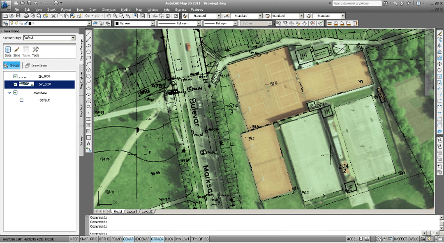
The data available through the geoportal includes digital orthophotos, base maps, administrative units, and land survey information (Figure 1).
Technically, the iGEO geoportal offers web services allowing access to the most precise base map data. This data can be accessed by Bosnia-Herzegovinian local municipalities, government agencies and utility infrastructure organizations. The portal provides full catalogue service web (CSW) functionality via the CSW plug-in. The following standard CSW operations are currently supported:
- GetCapabilities
- GetRecords
- GetRecordById
- GetDomain
- DescribeRecord
The Internal Catalogue Store supports two metadata schemes:
- Dublin Core
- ISO Metadata Profile
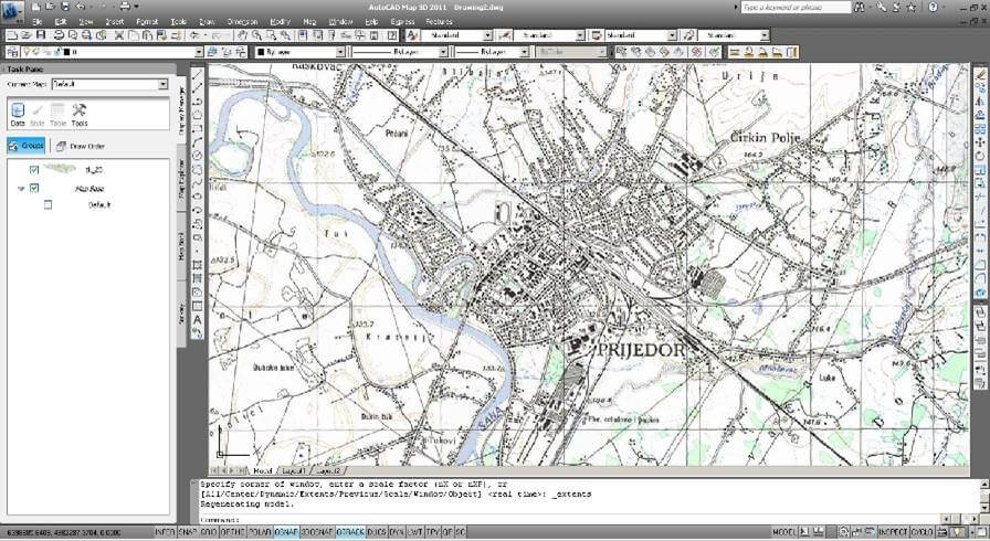
iGEO raster and vector layers are registered using metadata, which describes the location, age, quality, and other characteristics of the resources (Figure 2).
With access to this mapping material information, organizations can make decisions based on the best resources available. iGEO represents the geoportal component of the NSDI initiative in Bosnia and Herzegovina.
The Geoportal provides the datasets concerning the following aspects:
- administrative boundaries
- buildings
- cadastral parcels
- colored DTM
- scanned maps (regardless of map scale)
- geographical names
- hydrography networks
- ortho-photographies (regardless of resolution)
- railway networks
- road networks
- airports runways
- governmental buildings
- cadastral trigonometric points (levels I-IV)
Currently, we are working towards establishing interfaces with the GeoNetwork platform to enable setting up an INSPIRE view service with GeoNetwork and GeoServer.
The impact of iGEO - One Infrastructure, Many use cases
At this point iGEO-related experimental web services already handle data requests from local municipalities and utility companies, such as the Municipality of Banja Luka, the Municipality of Prijedor, the Municpiality of Gradiška, the Municipality of Teslić, M:Tel (telecommunications provider based in the Republic of Srpska), Vodovod i kanalzacija (RS-based local water and sewer company), Elektro-Krajina (regional electricity company), and many others.
There are two software projects under development based on the iGEO services geoportal as a principal data source: AreaCAD-GIS and BrownInfo. More iGEO-based specialized applications are envisioned and their planned architectures are at different stages of completeness by utility infrastructure organizations regionwide.
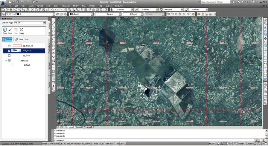
The web services provided carry detailed metadata on accompanying data layers, according to ISO/TS 19139-2:2012 Geographic information – Metadata standard based on OpenGIS Consortium (OGC) rules (Figure 3):
- Web Map Service (WMS)
- Web Feature Service (WFS)
- Web Coverage Service (WCS)
- Web Map Tiled Service (WMTS)
- Catalogue Services for the Web (CSW)
- Streaming KML
- Geography Markup Language (GML)
All data provided by iGEO are serviceable by all the before mentioned web services.
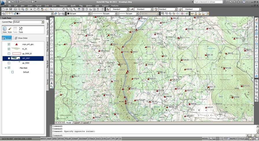
Figure 4. Point-wise vector layer visualization/cadastral trigonometric points over the topographic map layer
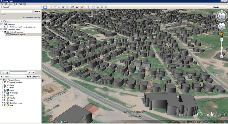
Figure 5. Streaming KML/KMZ services in Google Earth/Municipality Prijedor: 3D buildings and building metadata
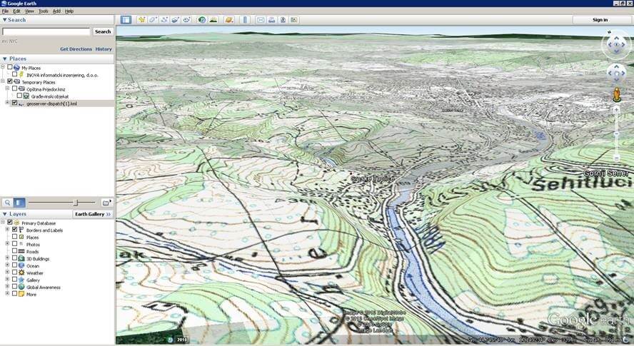
Figure 6. Streaming super-overlays in Google Earth/Municipality Banja Luka: topographic map draped over DTM
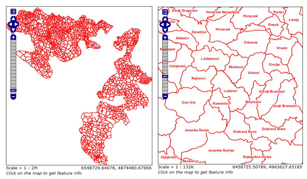
Figure 7. OpenLayers (web-based) representation of administrative boundaries of Republic of Srpska, Bosnia and Herzegovina
AreaCAD-GIS
AreaCAD-GIS is INOVA informaticki inzenjering's project representing a multi-tier GIS technology enabling organization-wide authoring and publishing spatial plans, metadata and design information quickly and easily for distribution, internally or on the web. The application targets municipal spatial (urban) planning departments’ productivity improvement and reduction of the time necessary for the issuing of building permits and tracking of their execution, as well as building legalization issues (Figure 8). It also serves as a bridge between a centralized municipal GIS repository and spatial planner acquisition tools by using various types of thin clients – to display acquired cadastral and urban data.
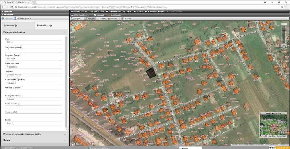
Figure 8. City of Prijedor's municipal AreaCAD-GIS Server web portal
AreaCAD-GIS utilizes iGEO-based web services to query and visualize Bosnia-Herzegovinian administrative data and topographic maps (Figure 9).
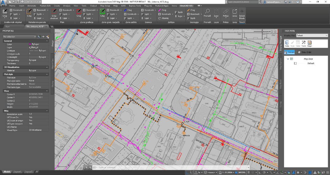
Figure 9. City of Banja Luka's municipal AreaCAD-GIS implementation running on the Autodesk Map 3D platform
BrownInfo
BrowInfo is a University of Banja Luka research project initiated with the aim of defining universal standards of identification, inventory and classification of brownfield sites. It aims to devise sets of effective methods for the collection, systematization, presentation and storage of brownfield-related data for use in the future as a basis for decisions on starting brownfield regeneration projects.
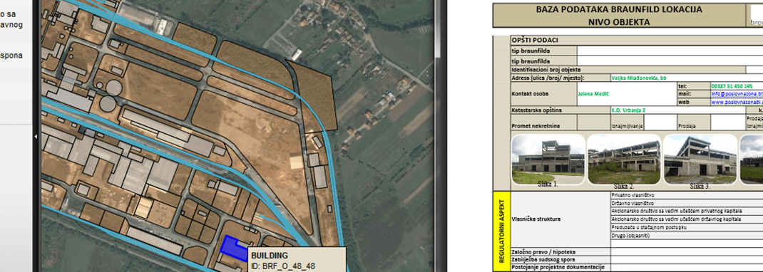
Figure 10. BrownInfo software implementation related to Business Zone Incel, Banja Luka
BrownInfo software utilizes iGEO-based web services to query and visualize utility infrastructure data and orthophoto maps for targeted Banja Luka region (Poslovna zona Incel/Business Zone Incel).
Conclusion and outlook
The main stakeholders have already been “inspired” in each country as well as at the European level, which has triggered many other initiatives. Awareness has been raised throughout the public sector and individuals and organizations have been encouraged to think about their roles and the datasets for which they are responsible.
All eyes are now clearly focused on the MS. Their experiences of implementing INSPIRE in the coming period will be crucial for the planning and preparatory activities already started for the review of the INSPIRE Directive. The efficient implementation of INSPIRE also involves cost–benefit considerations, which are a core part of the process. It is important to raise awareness, especially among users, of the need to monitor the benefits, which will not immediately be obvious.
In Bosnia and Herzegovina there is no official strategy for establishing NSDI, there are just borderline strategies at the entity level for Republika Srpska and the Federation of Bosnia and Herzegovina. Administrative borders and complex relations between these two entities have resulted in a situation in which we are still waiting for Bosnia and Herzegovina to officially adopt a national strategy for NSDI. Our idea for the future is that after adopting this strategy, iGEO portal will play the role of the core component for NSDI services.
The Federation of Bosnia and Herzegovina and Republika Srpska have not yet assigned a national geoportal, but significant progress has been made with the help of iGEO. The primary challenge faced by them in their INSPIRE Implementation is one that is faced by the majority of INSPIRE Implementers: data harmonization. This challenge, though, can be dealt with easily if the right tools such as hale»studio are at hand.