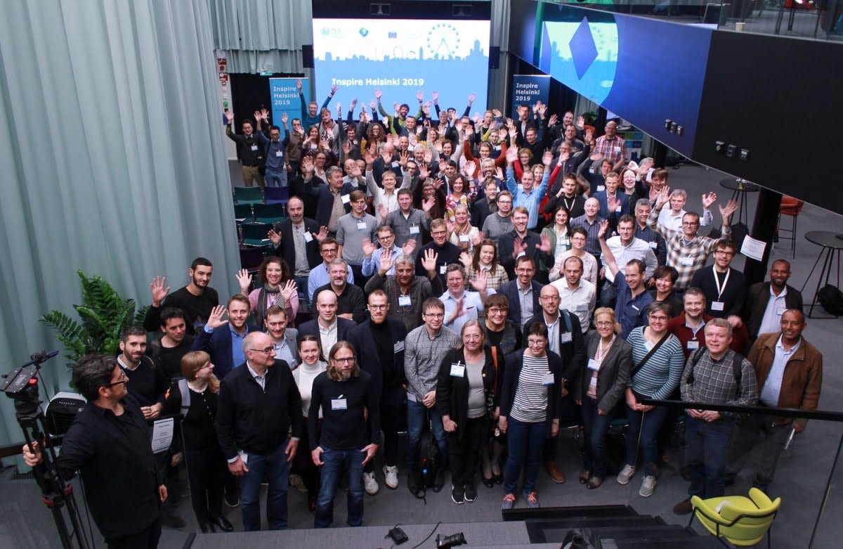
Let's INSPIRE Helsinki!

From 22nd to 24th of October, this year’s only international INSPIRE event took place in Helsinki, Finland. The goal of this event was to showcase actual applications, to open the INSPIRE community to more external people, and to provide training for INSPIRE implementers and solution builders.
Tuesday started with a set of refreshingly short addresses both from the local organising committees and from Michael Lutz from the JRC. Michel explained that the priorities of the incoming European Commission under the designated president Ursula von der Leyen are highly aligned to the INSPIRE effort. Aspects such as a new green deal, digital transformation in all of society, and the impact and regulation of Artificial Intelligence.
After the intro, Bart de Lathouwer, president at the OGC, talked about how easy-to-implement standards based on “mainstream” ICT approaches can democratize access to location data. In the same vein, he put a lot of emphasis on the “spatial is NOT special” mantra. The spatial community was quite a bit ahead of the curve, but right now it has a lot of rather peculiar approaches and standards that do not translate well to achieving interoperability with other business areas. I fully agree that “spatial” has been a walled off niche for too long. Other than that, I mostly found the glimpses Bart gave into what technologies and trends OGC is currently evaluating such as Edge Computing, Maps for CAVs, Geo IT Ethics and the impact of data science to be very interesting.
The second keynote was delivered by Hanna Niemi-Hugaerts, the Director for IoT at the Forum Virium. I found it very impressive to what her organisation and others have done to establish a true developer ecosystem in Helsinki and the surrounding areas. She explained what the roles open data and easy- to- use API played in that success story, but what I was missing was a clearer view about what role INSPIRE has already played or could play in that ecosystem.
After the keynotes, we were all treated with a short intro into to all challenges. Out of these presentations, the “Find the best seaside vacation spot” presentation clearly stood out as an excellent example how to communicate the benefits of an undertaking like INSPIRE to a wide audience. We then all enjoyed a nice dinner, with an “acapella” finale courtesy of the “Three Wise Men”.
Second day, workshop day! Wednesday had three parallel tracks, one focused on challenge entrant presentations, and two full filled with workshops. In the morning, there was an in-depth workshop on GeoServer and hale studio. Quite a few people I met discussed this workshop and the general approach to use hale studio, Geoserver and the app-schema extension to provide INSPIRE compliant data and services, and I realized that due to the multi-stage nature of the process, many people still view it as a complicated process – and mostly blame hale studio for not making it easier ?.
In the afternoon, there were several workshops that I anticipated highly. The first one was from Peter Baumann, Kathi Schleidt and Jordi Escriu, and detailed how one might be able to implement INSPIRE compliant WCS 2.0 download services. This is definitely a topic for a separate, upcoming post. As the editor of the draft GeoJSON encoding rule for INSPIRE data, I was also anticipating the Esri-led workshop titled “Making INSPIRE Useable with ArcGIS and Alternative encoding”. It was very interesting to see Esri’s work on making spatial data more accessible through the Hub product, and to learn about new experiences that take spatial data as one component. The scope for which the encoding rule was presented, however, led to intense discussions. Maybe this would be another topic I need to write an article on in the next weeks…
Giordano Colombi from AELER Technologies, Christopher Hönn and me then concluded Wednesday with our workshop on “A Framework for building successful Solutions on INSPIRE”. This workshop built on our experiences in supporting AELER and others in building up real solutions on the INSPIRE Infrastructure. While attendance was a bit on the low side, we got a really engaged group and very interesting discussions, particularly on organisational readiness for INSPIRE-based solutions. One aspect we discussed in depth was the lack of clear licensing terms. Even when there are open data licenses, a case like using data for this challenge was usually not a good fit. In preparation for the challenge, we had reached out to 41 data providers, of which only 16 responded in an any way, and in the end, only 5 agreed to allow us to use their data for the challenge.
Thursday morning then started with my keynote presentation. I started with perspectives about what makes a platform successful. Then I transitioned into how the SDI we have now could evolve to become a distributed, open and effective platform that would transform spatial and environmental data from the underutilized resource it is right now to a key component of solving global challenges such as climate change, migration and biodiversity. Towards the end I had to speed up a bit to leave enough space for discussions. As hoped, there were a lot of thoughtful and interesting questions, which were later also picked up by the panel.
However, before the panel discussion it was time for a true highlight – the announcement of the overall winners across the three challenges. All three winning teams showed how INSPIRE data can be used to solve a wide range of problems:
- First place: Team Minerva Intelligence – Geohazards in Italy
- Second Place: Team West Coast Surfers – Floods in England
- Third Place: Team Statistics Finland – Best Seaside vacation spot
I was particularly impressed by Jake’s presentation of the entry from Minerva Intelligence. They showed the potential benefits of building on interoperable data and services most clearly. The team used a wide range of INSPIRE components,from extending the Natural Risk Zones model with “Susceptibility Zones”, added a detailed landslide classification taxonomy built with ACE to a codelist, and finally built their machine learning model on several fully harmonised INSPIRE data sets. Those data sets were harmonised using hale studio and were served as INSPIRE View and Download Services via hale connect. Minerva has been a customer of wetransform since July 2018, and the collaboration has been very productive and friendly.

After the challenge finals, the panel discussion and closing remarks came up, with a nice video greeting from DG ENV’s Joeri Robbrecht. I couldn’t help but notice the two wetransform postcards (you know, the limited 2016 and 2017 editions) in the background ?.
To me, the event felt very focused. I liked the fact that there were only three parallel tracks; now, not there was less of a risk of “missing out” on one of the interesting and helpful workshops or challenge presentations. I also really liked the concept of having INSPIRE challenges, though I think the format needs to be changed to be more attractive. The way it was, the effort-to-benefit ratio was apparently not that appealing to student groups or independent teams. On our end, obtaining the data for the challenge proved to be rather hard.
So, did the event achieve its objectives? I would say, partially. It was a meeting of the core INSPIRE community, with maybe 20 to 30 new faces. I personally judged the “outreach” to get new communities to adopt INSPIRE to be rather low. On the other aspects, it was successful. The workshops were of high quality and most people I talked to were very positive about them.
I very much enjoyed the hospitality of the NLS, the venue, the discussions, and the food. I already look forward to another event in Finland, though for now our team at wetransform focus on the WE User Forum (29th/30th of January 2020,Darmstadt, German language) and the INSPIRE 2020 Dubrovnik conference.
Here are a few other impressions from the event: