Planning for Zoning

May 18th, 2022 – About lunchtime
The sunny atrium of Fraunhofer IGD is pleasantly crowded with people, all gathered for the first in-person event in a very long time: wetransform’s XPlanung User Forum.

I grab a plate of food and steel myself to go chat to some people I don’t know, in my third language, about a topic I do not yet know much about. My gaze falls on a man in a snazzy blue suit, still standing alone at a table. He was one of the presenters, certainly he’ll be able to tell me more about this whole “XPlanung” thing!
Unbeknownst to myself, I approach Dr. Kai-Uwe Krause, one of the creators of XPlanung.
My knowledge of XPlanung so far can be summarised thusly: It’s a German spatial planning data standard our tools can transform other files into, and once that’s done compliance to INSPIRE is effectively automatic.
In almost no time at all, Dr. Krause teaches me a lot more.
The dream of XPlanung is a deceptively straightforward one: Use a single format and information model for all spatial planning, enabling easy exchange of planning data between planning authorities, engineers, and the public. Ideally, it should allow people to receive all relevant information with a single click.
I have worked with spatial data and data standards for long enough now to know that actually getting to that stage is not going to be simple at all. The data unfortunately confirms that.
But what makes it so difficult? So far only a few cities have fully implemented XPlanung. Hamburg, Freiburg, maybe a few more, but it’s early days yet. Of course, implementing a standard like this takes a non-trivial amount of effort as many plans are still in the analogue age. However, modern tools (such as hale»connect make the process a lot easier. Using our tool alone, more than 40.000 plans have already been processed and published! A solid move in the right direction, but hardly the one-click solution for all of Germany we’d like to see.
Could that even work?
As it turns out, it already works… in, for example, the Netherlands.
Of course! Germany is not alone in requiring a more accessible, digital way of allowing people access to planning and zoning information. For example, there’s Denmark, Belgium, Spain, and probably many more places where a similar system either already exists or is in the works.
I decide to take the Dutch portal for a test drive.
- I hit “search for plans” and a map of the Netherlands appears within a second or two
- On the left, there’s a search bar telling me to search for an address, so I enter a familiar one, aided by a swift dropdown as soon as I enter the street
- One click
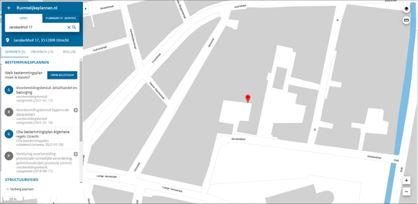
Suddenly, the screen jumps to the location of my old art school in Utrecht. As promised, I now have access to all planning and zoning information regarding the area on the municipal, provincial, and national level. I can see overlays, look at the relevant documentation, all at the click of a button!
But is it useful?
Fancy as this portal may be, the only way it adds value is if it is useful to the people working with these plans, be they corporations or individual citizens. To learn more about this, I would have to find someone nerdy and DIY-minded enough to have delved into their local planning permissions. Someone who would happily analyse a bunch of data to make an informed decision before launching into some madcap remodelling scheme or ensure every change in the neighbourhood was up to standard. Someone who wouldn’t just blindly leave these matters to chance or third parties.
So, I texted my dad.
And oh boy, is this portal useful!
A lengthy exchange, spilling over into a few phone calls, later I was ready to be passionate about things like gutter heights. Because those are important. You can find answers to big questions on the portal, like whether you can open a shop in a certain area, but also discover that small changes to your building plans are needed to comply with the local regulations. This in turn can save months’ worth of potential objection procedures or, worse, having to tear down and re-do things if a lack of compliance is discovered too late.
Of course, my dad tends to have an above average interest in these matters and the Netherlands is a particularly tiny and highly digitised nation, but as a proof of concept… it holds up.
No need to spend ages filing requests to check things, not even a need to leave the house. With all zoning and planning information available at the click of a button, a huge amount of time, effort, and money can be saved. Accessible even by an ordinary citizen.
Certainly, implementing these standards in larger nations will take time and effort as well, but it seems like precisely the type of advancement the JRC was talking about when they said that increased interoperability could allow governments and businesses to save upwards of €500bn.
With wetransform’s guidance and toolset, this dream of one click accessibility can be within reach faster and easier than ever before. Plus, compliance to INSPIRE is effectively thrown in as a bonus. As a resident of Berlin, I can feel the pinch of building regulations happen in real time, and I’m sure there are many in the world who feel the same way. So it’s time to get onboard – if you want to learn more about implementing standards such as XPlanung and INSPIRE in one workflow, reach out.