
InGeoDTM: Unlocking the Potential of Sensitive Geospatial Data

Greater access to geodata can drive many sectors forward, but when it comes to sensitive data, that access becomes a double-edged sword.
A forest inventory can help train a model that identifies tree species from satellite imagery, saving time and effort. It can also reveal commercially sensitive information about a forest owner’s assets. Infrastructure data can improve the planning and rollout of renewable energy systems or high-speed internet networks. It can also expose information that bad-faith actors could exploit to carry out sabotage.
In both cases, keeping the data inaccessible has an opportunity cost: useful applications may have to work with an incomplete picture, constantly re-request data, or simply never get built at all.
Over the past years, we have worked on making sensitive data available under conditions that providers can trust and users can actually work with. InGeoDTM (short for InGeo Datentreuhandmodell für horizontale Geodatenräume, or "InGeo Data Trustee Model for Horizontal Geospatial Data Spaces") gave us an opportunity to bring governance, methodology, and technical implementation together.
The collaborative project ran from 1 June 2024 to 28 February 2026. Fraunhofer IGD coordinated the consortium, working with Fraunhofer ISST, wetransform, DFKI, and M.O.S.S., with InGeoForum contributing as a subcontractor.
It was supported through the German Federal Ministry for Research, Technology and Space (BMFTR)'s programme for scaling and increasing the acceptance of cross-sector data trustee models, financed by the European Union’s NextGenerationEU instrument.
Total project funding: €1.48 million
Forestry and wind energy provided the practical application scenarios.
Why Geospatial Data Needs a Horizontal Approach
Many European data spaces are organised around sectors: mobility, agriculture, energy or health. However, their data requirements overlap substantially. Terrain, land ownership, vegetation, infrastructure, and environmental observations are relevant across several of these domains.
Consider wind energy planning in a forested area. It requires energy-sector expertise, but also information about forest stands, access roads, protected habitats, and cadastral parcels. Developing separate mechanisms for finding, harmonising, and securely accessing the required data in every sector incurs recurring integration costs.
Providers face the same problem from the other direction: supporting an additional application domain can mean implementing another connection, another policy model, and another onboarding process.

A horizontal approach allows these capabilities to be reused across sectors. Domain-specific applications can build on shared geospatial services, standards, and protection mechanisms.
Data trustees help make this approach accessible to organisations with limited technical capacity. Utilising these, a municipality or forest owner can mandate a trusted intermediary to provide data under agreed conditions, without having to operate a connector or independently manage every data space relationship. The trustee combines technical services with responsibilities for stewardship, transparent governance, and the handling of entrusted data.
A Blueprint That Goes Deeper
The InGeoDTM blueprint describes how to implement this approach. It connects the organisational model of a trustee with the processes and software required to share geospatial data according to their protection needs.
It covers roles, responsibilities, onboarding, data descriptions, usage agreements, and policy enforcement. Its technical implementation combines Eclipse Dataspace Components (EDC), Keycloak-based identity management, catalogues, and established geospatial interfaces such as OGC API Features. The architecture follows Gaia-X and IDSA concepts, while retaining the interfaces that geospatial applications already understand.
At wetransform, we led the technical blueprint work package. We brought together data publication, harmonisation, identity management, connector integration, and spatial policy enforcement, extending the existing scalable and robust hale»connect platform towards a ready-to-use trustee implementation.
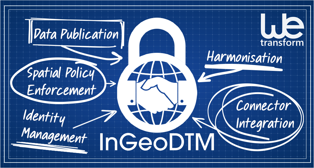
This implementation introduces a complete path from publishing a resource to consuming it under agreed conditions. Providers register a geospatial service and attach policies. Consumers discover the offer, establish an agreement through connectors, and access the permitted data. The forestry demonstrator showed spatially restricted access in QGIS; the wind energy demonstrator applied the approach to planning workflows.
Governance remains essential throughout. The consortium’s research identified five principles for trustee governance: trust, independence, compliance, value-adding services, and stewardship. These help define what organisations should expect from the intermediary they entrust with their data.
Finding Policies That Preserve Value
One of our most important contributions was methodological: an extended analysis of protection needs and reuse potential, referred to as Schema-Based Sensitivity Analysis Template (SBSAT).
The starting point for this analysis is a concrete damage scenario. Which specific loss of confidentiality, integrity, or availability could cause harm, to whom, and through which disclosure or processing operation? What are the plausible consequences? We then examine the intended use: which attributes, spatial relationships, and levels of detail does it actually require?
This makes policy selection much more precise. A dataset may contain harmless attributes alongside commercially sensitive information. Its exact location may be essential for one application and unnecessary for another. Restricting the whole dataset uniformly can remove much of its value without addressing the actual risk particularly well.
Forest inventory labels illustrate the problem. Training a remote-sensing model requires an accurate relationship between observations on the ground and imagery. Moving the coordinates can break that relationship. The blueprint therefore also describes processing within a trusted environment, where precise source data are combined before derived training products are released. The protection assessment must cover those outputs as well.
Our joint research with Fraunhofer ISST adds empirical evidence. In a 2026 paper, we compared 11 spatial anonymisation methods using 2,147 forest cadastral parcels, examining privacy and utility metrics and translating recommendations into ODRL policies. The evaluation exposed failure modes and showed benefits from hybrid approaches. My reading of these results is that selecting an algorithm is only part of the task: its parameters, the spatial distribution of the data, and the intended application all matter.
“Optimal” policies therefore depend on the use case and threat model. The method helps select and justify measures that address identified risks, while retaining the information needed for useful work.
From Location Privacy Policies to Enforcement
We defined reusable Location Privacy policy patterns for recurring choices involved in:
- limiting access to an authorised geographical area;
- retaining geometry while removing sensitive attributes;
- retaining attributes while removing or pseudonymising location;
- reducing positional accuracy;
- aggregating observations into larger spatial units.
These patterns can be expressed through ODRL, the policy language used in most data space connectors. Geofencing, for example, allows different organisations to access different geographical subsets of the same underlying resource.
A machine-readable agreement still needs an implementation that applies its conditions. We therefore implemented the Location Privacy Proxy, a specialised Policy Enforcement Point. It sits in the data access path and applies spatial restrictions to requests and to the responses from the underlying geospatial service. In the implemented geofence scenario, the consumer receives only features permitted by its spatial authorisation.
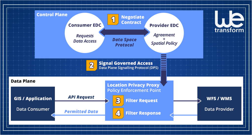
This connects two layers that need to work together: the control plane establishes the agreement, while the data plane applies the relevant conditions during access. The source service is protected against direct consumer access that would bypass enforcement. Users can work through familiar tools such as QGIS.
There is also a clear boundary to technical control. Once an authorised recipient exports data beyond the controlled environment, subsequent obligations require contractual and organisational safeguards. Policy design must account for that boundary from the beginning.
Carrying the Work into SAGE and New Proposals
InGeoDTM’s results are being carried forward through SAGE, the Horizon Europe project implementing the Green Deal Data Space. We contribute to its architecture, lead work on value-added services, and develop the Forest Transformation use case. Our plans include integrating the hale»connect-based trustee as a service that helps organisations contribute data assets.
The Forest Data Space provides a concrete setting for this transfer. Its planned combination of forest inventories, satellite observations, and other environmental sources requires both interoperability and controlled access. The blueprint, policy methodology, and enforcement components provide a foundation to make sensitive inputs usable across organisational boundaries.
We are also taking these ideas into new proposal concepts for agentic digital twins and automated environmental compliance. Here, the intended reuse is specific: agents need to discover relevant data and services, assess their fitness for a task, and access them under enforceable conditions. These remain proposed extensions, building on the infrastructure and methods already developed.
Try It with Your Own Data
The trustee implementation is available to explore in a sandbox. If you hold useful geospatial data that cannot be published openly, bring us a dataset and a concrete application. We can work through its protection needs, identify suitable policies, and demonstrate how authorised users can access it through familiar geospatial tools.
You can also use the sandbox to assess establishing your own trustee service or connecting existing infrastructure to a data space.
We would be happy to help you turn an underused dataset into something people can safely put to work.
» Get in touch to try the InGeoDTM trustee.